 Syken metatietopalvelu
Itämeren ja Suomen järvien päivittäinen sameusaineisto (Landsat-8/9) 2016– / Daily turbidity of the Baltic Sea and Finnish lakes (Landsat-8/9) 2016–
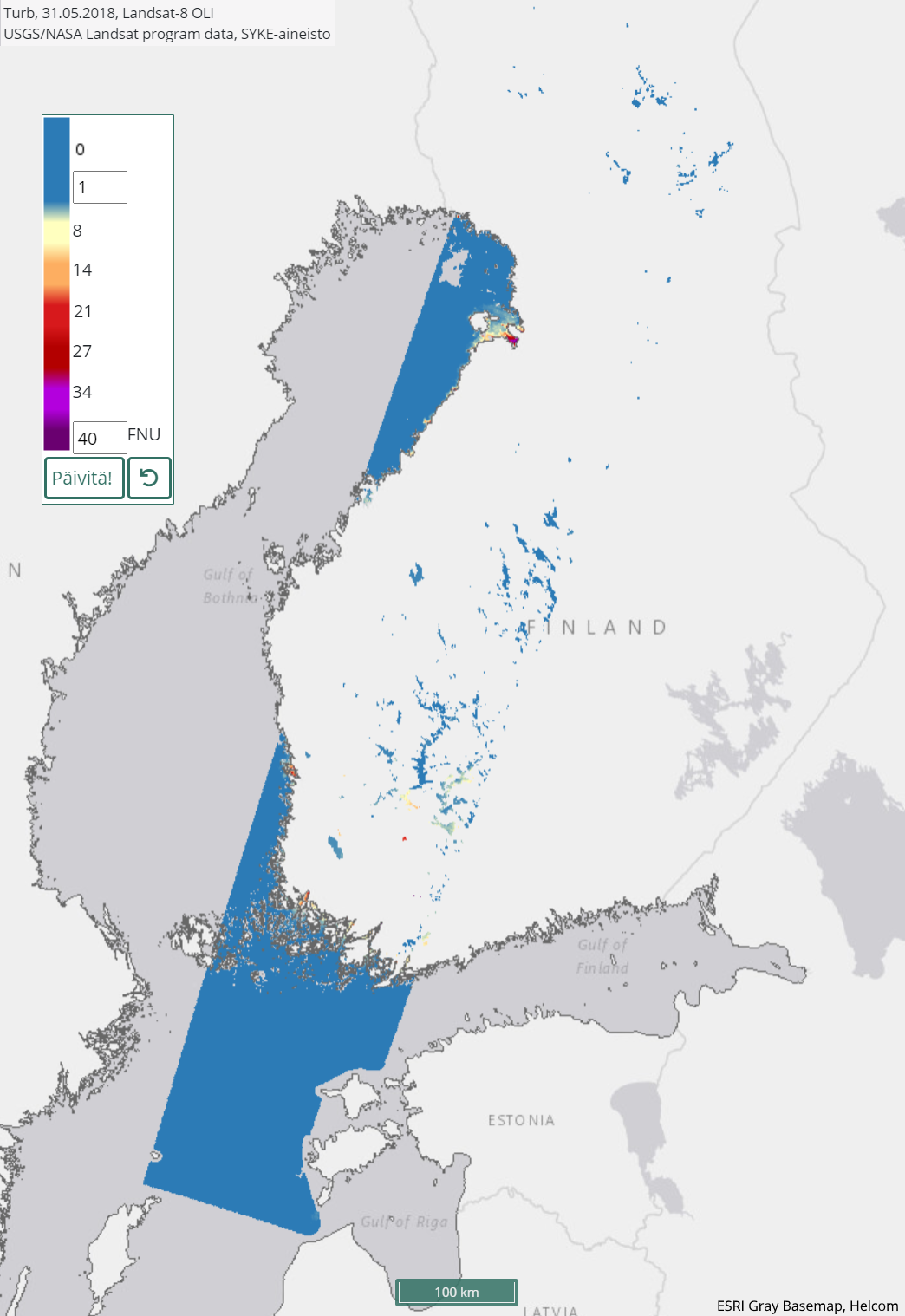
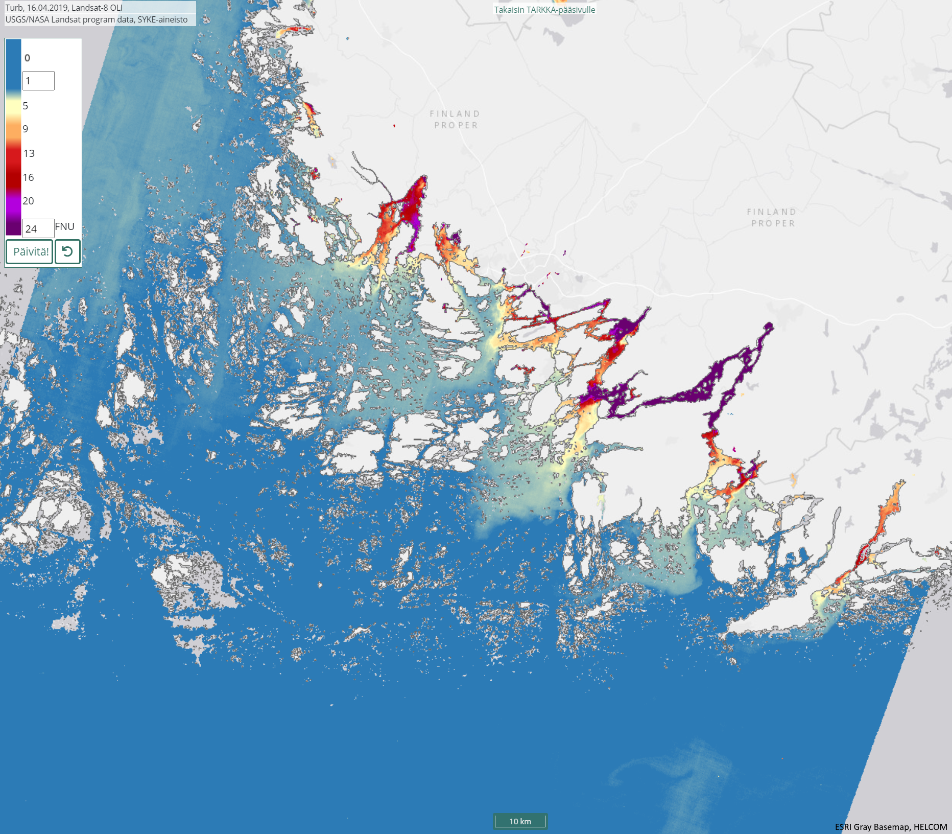
[FI] Satelliitti-instrumenttien havainnoista seurataan veden sameutta pilvettömiltä alueilta sulan veden aikana Suomen merialueilta ja järviltä.
Sameushavainnoissa näkyy usein luonnollista vaihtelua, kuten jokien rannikkovesiin tuoma maa-aines tai voimakkaiden tuulien aiheuttama resuspensio, joka nostaa sameaa vettä pohjasta pintaan.
Tämä aineisto koostuu NASAn ja U.S. Geological Survey (USGS) Landsat-8 -satelliitin OLI-instrumentin havainnoista vuodesta 2016 lähtien sekä Landsat-9 -satelliitin OLI-2 -instrumentin havainnoista vuodesta 2022 lähtien. Tulkinta tehdään 60 metrin tarkkuudella. Havaintoja on saatavilla keskimäärin 8 päivän välein satelliitin ylilentoradoista riippuen. Vastaava sameustulkinta tehdään myös EUn Copernicus-ohjelman Sentinel-2 sarjan MSI-instrumentin aineistoista (erillinen metadata).
Sameuden tulkinta perustuu satelliitti-instrumentin havaitsemaan vesialueelta tulevan auringon säteilyn heijastukseen, joka on suurempi sameilla vesialueilla kuin kirkkailla alueilla. Sameuden tulkinta tehdään mallilla, joka perustuu neuroverkkoon (C2RCC, Brockmann et al. 2016; Doerffer et al. 2007; 2008a; 2008b). Malli on avoimesti saatavilla SNAP-ohjelmiston kautta. Syke:n aineistoissa mallin lopputulos on kuitenkin sovitettu vastaamaan Suomen rannikko- ja järvialueiden optisia ominaisuuksia. Sovitus perustuu kenttäkampanjoihin ja ympäristöhallinnon asemanäytteenottoon rannikolla ja järvillä (perusperiaate kuvattu Attila et al., 2013).
Käyttötarkoitus: Itämeren ja Suomen järvien vedenlaadun seuranta.
Aineisto kuuluu SYKEn avoimiin aineistoihin (CC BY 4.0).
***
[EN] Satellite observations are used to monitor turbidity of water from cloudless regions during meltwater from Finnish sea areas and lakes.
Turbidity maps often show natural variation, such as soil brought into the coastal waters by rivers or resuspension caused by strong winds, which raises more turbid water from the bottom to the surface.
The turbidity interpretation is based on the reflection of solar radiation from the water area detected by the satellite instrument, which is higher in turbid water areas than the water reflection in bright areas. The data is made with an accuracy of 60 m. The interpretation is based on observations from the OLI instrument of the NASA and the U.S. Geological Survey (USGS) Landsat-8 starting from year 2016 and OLI-2 instrument of the NASA Landsat-9 satellite starting from year 2022. Corresponding turbidity interpretation is done also for the Sentinel-2 series MSI instruments, separate metadata.
The estimation of turbidity is produced with a model based on a neural network (C2RCC, Brockmann et al. 2016; Doerffer, et al. 2007; 2008a; 2008b). The model is openly available through SNAP software. In Syke's data, however, the final result of the model has been adapted to correspond to the optical properties of the Finnish coast and lake areas. The adaptation is based on field campaigns and station sampling (as exemplified e.g. in Attila et al., 2013).
***
## Viitteet / References
Attila, J., Koponen, S., Kallio, K., Lindfors, A., Kaitala, S., & Ylöstalo, P. (2013). MERIS Case II water processor comparison on coastal sites of the northern Baltic Sea, Remote Sensing of Environment, 128, 138–149.
Brockmann, C & Doerffer, R. (2016). Evolution of the C2RCC neural network for Sentinel 2 and 3 for the retrieval of ocean colour products in normal and extreme optically complex waters. Proc. Living Planet Symposium, ESA SP-470.
Doerffer, R. & Schiller, H. (2007). The MERIS Case 2 algorithm. International Journal of Remote Sensing, 28 (3–4), 517–535. doi:10.1080/01431160600821127.
Doerffer, R., & Schiller, H. (2008a). MERIS Regional Coastal and Lake Case 2 Water Project Atmospheric correction ATBD (Algorithm Theoretical Basis Document) 1.0. 41 p.
Doerffer, R. & Schiller, H., (2008b). MERIS Lake Water Project - Lake Water Algorithm for BEAM, ATBD (Algorithm Theoretical Basis Document) 1.0, 17 p.
***
**WMS-palvelin / WMS service endpoint**: https://geoserver2.ymparisto.fi/geoserver/eo/wms
**WMS-taso / WMS layer**: EO_HR_WQ_LC8_TURB
***
Simple
Identification info
- Title
-
Itämeren ja Suomen järvien päivittäinen sameusaineisto (Landsat-8/9) 2016– / Daily turbidity of the Baltic Sea and Finnish lakes (Landsat-8/9) 2016–
- Date (Publication)
- 2016-04-14
- Point of contact
-
Organisation name Electronic mail address Role Suomen ympäristökeskus / Finnish Environment Institute (Syke)
Point of contact
-
SYKE resource classification
-
-
Satelliittihavaintotieto
-
- Keywords
-
-
Ei-Inspire
-
TARKKA
-
STATUS
-
status assessment
-
Resource constraints
- Use constraints
- Other restrictions
- Other constraints
-
Creative Commons Nimeä 4.0 Kansainvälinen
[FI] Syke on mainittava lähteenä, jos tuotteita käytetään julkaisuissa tai esityksissä tai saatetaan muulla tavoin yleisön saataviin.
Landsat-8/9 aineistoihin perustuva sameus: "Syke-aineisto, USGS/NASA Landsat Program (vuosi)"
Lisätietoja: https://wwwi4.ymparisto.fi/i4/fin/eowiki/aineistojen_kayttoluvat.html
***
[EN] Syke must be cited as a source if the products are used in publications or performances or otherwise made available to the public.
Turbidity based on Landsat-8/9 data: "Syke data, USGS / NASA Landsat Program (year)"
More info: https://wwwi4.ymparisto.fi/i4/eng/eowiki/license_information.html
- Access constraints
- Other restrictions
- Other constraints
- no limitations
- Spatial representation type
- Grid
- Metadata language
- English
- Topic category
-
- Environment
- Inland waters
- Oceans
Temporal extent
- Begin
- 2016
Spatial extent information
))
- Unique resource identifier
- EPSG:3067
- Codespace
-
EPSG
- Distribution format
-
- GeoTiff ( -)
Digital transfer options
- OnLine resource
-
Protocol Linkage Name https://www.syke.fi/tarkka Tarkka-palvelu/service
https://geoserver2.ymparisto.fi/geoserver/eo/ows?service=wms&version=1.3.0&request=GetCapabilities GetCapabilities-dokumentti
https://geoserver2.ymparisto.fi/geoserver/eo/wms?service=WMS&version=1.1.0&request=GetMap&layers=eo:EO_HR_WQ_LC8_TURB&styles=&time=2019-04-16&bbox=19999.9999999997,6597200.0,739760.0,7836740.0&width=445&height=768&srs=EPSG:3067&format=image%2Fpng%3B%20mode%3D8bit WMS-esimerkki / WMS example
https://wwwi4.ymparisto.fi/i4/fin/eowiki/aineistot_aineistot.html Lisätietoa Syken EO-wikissä
https://wwwi4.ymparisto.fi/i4/eng/eowiki/datasets_start.html More information in Syke's EOwiki
https://www.syke.fi/fi/ymparistotieto/avoimet-rajapinnat/satelliittihavaintojen-rajapinnat Satelliittihavaintojen rajapinnat / EO Web Map Services
- Hierarchy level
- Series
- Statement
-
[FI] Kaukokartoitusseurantojen tuloksena syntynyt sameustulkinta. Vuodesta 2016 eteenpäin koostuva Suomen merialueilta ja järviltä.
Prosessointihistoria:Landsat-8 OLI ja Landsat-9 OLI-2 alkuperäinen satelliittidata on ladattu USGS/NASA latauspalveluista. Sykessä niistä on laskettu sameustulkinnat käyttäen C2RCC-mallia (Case-2 Regional CoastColour).
***
[EN] Satellite observations are used to monitor turbidity from years 2016- for the Finnish sea areas and lakes.
Processing history: The Landsat-8 OLI and Landsat-9 OLI-2 data have been received from USGS/NASA service. The dataset has been processed to turbidity values in Syke using the C2RCC algorithm (Case-2 Regional CoastColour), which includes atmospheric correction.
Metadata
- File identifier
- {7387219C-C9E2-4613-A84D-76FD69F04BD5} XML
- Metadata language
- Finnish
- Character set
- UTF8
- Hierarchy level
- Series
- Date stamp
- 2026-11-18T13:01:34.602967Z
- Metadata standard name
-
ISO19115
- Metadata standard version
-
2003/Cor.1:2006
- Metadata author
-
Organisation name Electronic mail address Role Suomen ympäristökeskus / Finnish Environment Institute (Syke)
Point of contact
Overviews
Spatial extent
)))
Provided by
